A series of articles on Peckforton Mill by David Keogh
Peckforton Mill -1
Peac ford tun: ‘farm by a ford near the Peak’
In 2018, I finally confirmed the existence of a 14th century watermill on the R.Gowy at Hockenhull. The field-name Millfield on the tithe 1839 map was the starting point as it was for Peckforton. The tithe survey was the first such record since Domesday in 1068.
For such a small river, the Gowy sustained a surprising number of mills. Those at Stamford, Trafford, Bunbury and Huxley are well-documented though others have gone completely. The frequency of millfield suggested hundreds of mills once stood on small streams and rivers such as the Gowy.
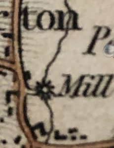
Tracing the source of the Gowy produced a real surprise – the remains of Peckforton Mill. A survey by Norris (1965-66) recorded ‘a site with small remains of wheel position ‘; in reality there were a good deal more. Another by Bott gives a 1363 place-name record and map evidence for 1775 through to the 1846 tithe. Might there have been a 14th century mill or an even earlier one?
There were 264 settlements in Domesday Cheshire yet only 25 mills were recorded. Four on the Gowy at Stapleford, Christleton, Great and Little Barrow (2). Peckforton is recorded but no water or windmill.
Wulfric, a free man, held it. 1 hide paying tax.
Land for 2 ploughs. 1 villager with 1 plough.
The value was 8s; now it pays 20s.
Today, there are remains of a watermill and a windmill field is also shown on the tithe map (see below)
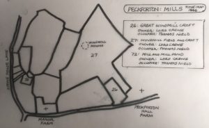
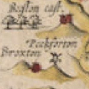
Bott also gives a watermill, on Horsley Lane and two more at Beeston. To support three mills on the Gowy so close to its source points to a more powerful river. Nearby were mills at Bickerton, Bulkeley, Bunbury and Spurstow, and some windmills too. The early maps of Speed 1610 and Morden 1772 show a windmill on the Peckforton Hills on a hill next to Broxton.
Apparently, the windmill at Peckforton was moved to Luddington Hill, north of Tarporley above the A49.
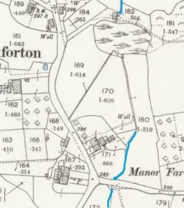
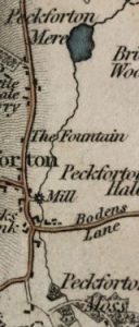
Bott’s major survey was based on documentary and map evidence rather than fieldwork. One map, Bryant’s 1831, provides the most accurate location of Peckforton Mill. Notice the Gowy flowing north-eastwards.
Peckforton Mill- 2
The following research does not include any reference to the Tollemache estate papers held at Chester Record. Rather it is the result of map interpretation and fieldwork
.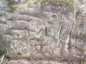
This inscription on the left wall of the mill, after a consensus of views, is for 1698. No mill or miller is recorded in the 1857 Post Office Directory. Spurstow and Beeston had one but not in 1875. All other Gowy mills are mentioned, in Kelly’s, from 1857 onwards. In 1890, the Peckforton Estate bought Bunbury Mill. This date and others offer clues to the demise of Peckforton Mill and will be considered in Part 3.
The mill is contemporary to the earliest dwellings in the village. A small mill driven by a mill-pool would have been familiar on the Gowy in the 17th century. It was built of local sandstone (and brick) by an estate worker or even a mason.
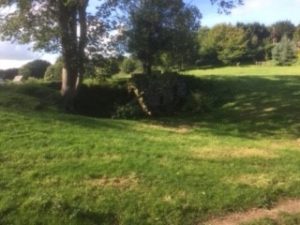
The site of the mill is rather odd. It sits in a hollow with a level field behind and slopes away ahead of it; the mill-pool has gone. No appreciable break in the gradient exists to power water to the mill. Either the Gowy was more powerful or the mill-pool was deep enough to provide a strong head of water. With such a small population it may have been producing animal feed rather than bread.
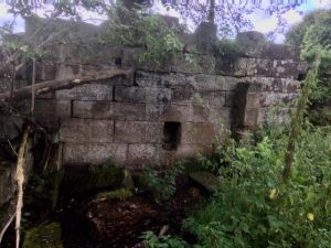
Mill backwall showing two small floor joint holes
When the mill ceased the mill-pool gradually became a marsh and a refuse dump then infilled. A good deal of the sandstone blocks has been removed from the mill. What remains suggests the mill stood some 7m high and 6m wide with curving embanking stone walls on either side adding a further 6m. Behind the mill a 3m wide sandstone dam wall separated a large mill-pool and gave access to the upper floor of the mill. The mill may have looked like this:
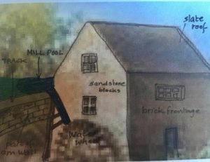
Most of the building used large dressed sandstone blocks though not of the best quality. The roof may have sloped more acutely than illustrated; rather like a lean-to.
Two half-buried millstones were a surprising find. These are possibly of coarse rock such as Millstone Grit. Without expert opinion the best guess is they originated in the Peak District.
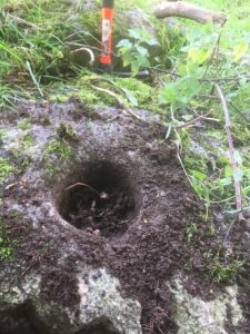
The stones are over a metre across, 14 cm thick with a large centre hole and extremely heavy, and would sit on the upper floor of the mill.
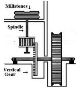
During the medieval period France provided the best stones for milling grain. These ‘burr’ stones measured up to 2m in diameter, weighed close to a tonne and only the manorial lord could afford them. Millstones of the 19th century, however, were both less costly and smaller like those at Peckforton when Lord Crewe owned it in 1846.
Whether a windmill was still functioning at this time is unlikely as the one at Spurstow (see plots:293 and 411 Tithe map) had gone. The two parishes had both types of mill and it is possible the milling at the watermills took over as the windmills ceased. It is thought ‘auxiliary’ windmills supported watermills at times of low summer water levels or if the river froze in winter as happen at various mills on the Gowy.
In Part 3: The changing Gowy through map interpretation and fieldwork
Peckforton Mill -3
Bryant 1831

This is a wider map view of the mill area and the R.Gowy. Bryant’s maps are generally regarded as the most accurate of the 19th century.
Here, the river is flowing directly to the mill then swings diagonally to Peckforton Mere, not directly north. This might be significant if the accuracy is accepted. Fifteen years later, in the tithe survey of 1846, the surveyors omitted the river for some inexplicable reason.
Tithe Map 1846
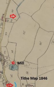
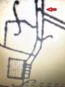
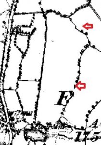
The Gowy is missing! Notice how the top arrow shows the river along the field boundary heading north whereas today it turns east at this point. Curious.
Did the Gowy follow another course or did it branch into two?
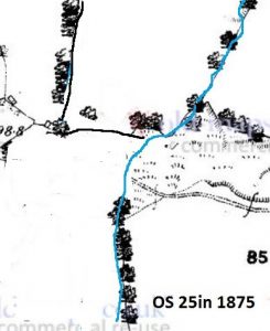
O.S.1875
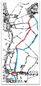
The Gowy flows directly north from the mill before making what seems an unnatural turn west. Did the river have two channels? The one (red) shown by Bryant dried up, or intermittent and the other channel altered to carry the flow from the mill? Clearly, the straightness of the river from the mill is a sure sign of control to increase the flow.
Was the course of the Gowy further east centuries before?
A feature barely visible on the above map is the overflow flow from the mill-pool (below) that later forms part of a diversion of the Gowy. The assumption is the course continues as before. However, the mill does not continue as evidenced in the 1898 OS map.
Was there an earlier mill on the site or further downstream; at the turn east perhaps?
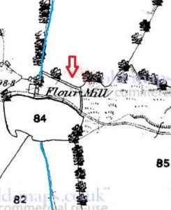
O.S. 1898
With the mill-pool now a marsh, the mill ceased about 1890, or a little earlier, as in 1890, the Peckforton Estate acquired Bunbury Mill.
O.S. 1910
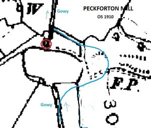
On the 1875 map the first diversion of the Gowy was proposed. Now again, the Gowy has been diverted around the mill-pool but also on a new course. This must mean it was diverted further upstream possibly by, or above, Peckforton Hall Lane
Peckforton 4: Gowy changes course
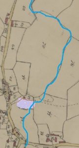
A comparison of the 1839 Tithe map and the 1875 OS map illustrates a change in the course of the Gowy.
Thirty-six years later it moved to the east. For a small river to cut a new course in such a short time is surprising. What determined this is a matter of conjecture.
- The river diverted naturally;
- Human intervention caused the diversion;
- An earlier course once existed.
Today, the flow of the Gowy need not reflect the way it was a century ago. Indeed, historically, as the river had mills close to its source this suggests it being more powerful. There is no way of knowing how the river behaved many centuries ago. For the river to cut a new course in such a short time suggests its flow was faster, more erosive and less likely to meander. Both maps show no hint of meanders indicative of a slow flow rate. Cheshire tithe maps including the Gowy always record meanders. However, the relative straightness of the river through Peckforton, Beeston and, to a lesser degree, Tiverton, could mean the river was controlled.
Controlling a river by diversion or channelization is usually to preventing flooding. Where streams or rivers silt-up or change course naturally, watermills may need a new channel to be created. Generally, most mills used artificially dug channels called leats, to provide a secure flow. Some leats can be very long and either become drains or filled when the mill closes.
A curious feature of the Gowy is it sinks in places below the surface. Might this be the reason for the omission of the river on the tithe map?
Could the reason be the Gowy was either intermittent or entirely subsurface or, the river was being channelised to maintain a secure flow to the mill? The tithe surveyors may well have be uncertain as to the exact line the river was to take.
Peckforton 5: The Gowy
Maps and aerial photographs are essential in interpreting the landscape. Early 17th century maps are pictorial and cannot accurately present detail such as small rivers like the Gowy. Only John Speed’s 1676 map, shows the Gowy. Not until the Peckforton Tithe Map and Award (inventory) could the Gowy be tracked from source to the sea.
……………………………………….
The main body of this research has been considered but other elements remain including new findings relating to the mill and the Gowy in the 18th century. Can a scenario be proposed for the river before the earliest map evidence?
The Mill and Mill wheel
This abstract from the OS 25in 1911 map for the first time depicts the mill wheel. Also, the mill is bigger than first thought as it extends nearer to the field boundary still present today. Arrowed is a sluice to control water-levels and the flow of the river.
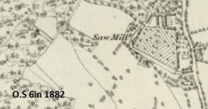
Before focusing on the Gowy, a claim that the mill was used as a sawmill needs attention. Watermills were often altered to sawmills as a plentiful supply of water was essential. Peckforton sawmill was set in the woods above Stonehouse Lane.
Creating a past scenario of the Gowy is set within the context of climate change and human intervention. Today, the landscape is the most recent layer of these primary factors. Interpreting maps needs geographical knowledge and imaginative visualisation to see beyond the present landscape.
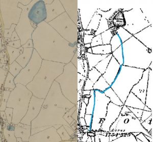
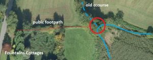
Once there were two courses (possibly more) of the Gowy. The old course was mapped in 1951 and 1959; seemingly not recorded before or after.
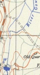
Minor rivers and streams are rarely shown on early maps. Today, this ‘lost’ course of the Gowy is regularly followed by walkers. Now just a field ditch overgrown and anonymous it disappears at the stile leading to Peckforton Moss. A field boundary marks the old course.
Early Gowy and its diversions
Returning to Bryant’s 1831 map, the old course is the one shown and likely to have existed before the mill was built in the late 17th century
The Gowy has small meanders due to crossing land with a low gradient. Possibly minor tributaries were not mapped.
Mill diversion
The river was diverted to first build the mill-pool. Its retaining wall required excavating an area deep enough to provide a steady flow to drive the mill wheel. The mill was set against the dam wall along which carts carried grain to the upper floor to supply the millstones below.
This assumes there was no earlier medieval mill, built with the abundant local timber, powered directly by the Gowy, on the same site. Such mills in Cheshire often preceded a stone one but, as with timber windmills, none have been found.
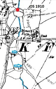
Gowy turns east
Large undressed sandstone blocks are present where the old course ends and the present Gowy turns east. Maybe randomly deposited but considered here they were used to direct the river from its old course. For whatever reason, the old course above this point was abandoned.
The Gowy long before the mill?
The final research presents the last chapter in the story of the Gowy.
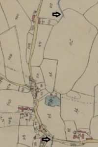
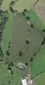
No fields in the near vicinity are like the one arrowed on the map.
This snaking field boundary suggests the river at a time beyond Speed’s 1610 map to even the medieval period. It can only be guesswork but may find some virtue.
Might this be how the Gowy was in about the 15th or 16th century? Using the revised tithe map, the river follows the fields to the east of today’s course. An aerial image shows what is now a ploughed in ditch.
One last image of a marsh about where the Gowy and the later mill site was.
Might this have been a natural change of course or just a empty theory?
*************************************************
IMPORTANT: No miller is recorded in Post Office or Kelly’s Trade Directories.
*************************************************
.